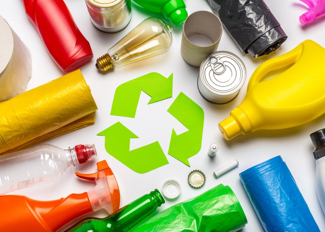
MSUcares Extension Header Return to MSUcares Home Page

Recognizing Wetlands
In the Gulf of Mexico Region

Regulatory Definition of Wetlands

"Those areas that are inundated or saturated by surface or ground water at a frequency and duration sufficient to support, and that under normal circumstances do support, a prevalence of vegetation typically adapted for life in saturated soil conditions" (EPA, 40 CFR 230.3 and CE, 33 CFR 328.3).


What Are Wetlands?

Wetlands are places within the landscape where water accumulates long enough to affect the condition of the soil or substrate and promote the growth of wet-tolerant plants. Places called wetlands include rivers, creeks, swamps, marshes, bogs, and similar areas, which, in effect, are components of the drainage system of the land.

By recognizing wetlands as parts of a drainage system, it can be more easily anticipated where these areas can be found within the landscape and to begin understanding the important functions that wetlands provide wildlife and humans.


Recognizing Wetlands

Three factors used to define wetlands include the presence of water, hydric soils, and wetland plants. These are also factors used to recognize or describe wetlands within the landscape. Of these, the presence of water is the most important factor -- given its role in the formation of hydric soils and, with hydric soils, its role in promoting the growth of wetland plants. The illustration shows the interrelationships between these three factors and the primary role played by water. Identifying wetlands and delineating the boundaries between wetlands and adjacent non-wetland areas involves the search for evidence of all three criteria.


Water

The presence of surface water is an obvious component of wetlands such as ponds, lakes, and streams. A number of other wetland types, however, might have standing water or saturated soils only on a seasonal basis. These seasonally wet areas include some types of swamps and savannas. These wetlands undergo a yearly cycle that ranges from wet conditions when standing water is present and soils are saturated to periods when soils are dry. The length of wet or dry periods might vary from year to year, and some years parts of the cycle might be absent.

When there is no standing water or saturated soils, other evidence for the presence of water is used to describe these wetlands. Such evidence includes watermarks on trees, or the presence of hydric soils. Watermarks can consist of dried sediment that coats the base of trees or watermarks can take the form of a "moss" line consisting of the lower limit of growth of common mosses found attached to tree trunks.

In seasonally wet wetlands that have no trees, the presence of water is usually inferred from the presence of hydric soils that are formed under frequent (yearly) and relatively long (weeks) periods of soil saturation.


Hydric Soils

The term "hydric" reflects the effect water (from the Greek root hydro) can have on a soil or substrate when present (constantly or seasonally) for extended periods of time (typically requiring years, decades, or longer). Under this condition, the chemistry of the organic (carbon-based) and inorganic (mineral) components of the soil is said to be in a reduced state (i.e., without oxygen), and many biological processes, such as decomposition of organic matter, are slowed. Alternately, in the presence of oxygen, these components might become oxidized (i.e., oxygen chemically bonding with these components). These processes are often accompanied by a change in color of the soil itself. Soils that contain large amounts of iron, for example, are typically reddish in color, reflecting the "rusting" or oxidation of the iron. These same soils, if found in wetland areas that have been exposed to saturated conditions for long periods of time (years), will be in a reduced state and will be grayer in color. In many cases, hydric soils will show a mottled appearance of alternating gray and reddish (oxidized) areas that reflect an alternating pattern of wet and dry periods. Organic materials, such as dead leaves, also will take on a dark color under saturated or reduced conditions. Because of the effect reduced or anoxic conditions have on the color of soil or substrate, color is used to identify hydric soils (through the use of soil color charts). Because of the previously discussed relationship between water and soil conditions, the presence of hydric soils is often used as an indicator of soil type and the presence of water.


Vegetation

The presence of wetland plants is a function of the influences of water and hydric soils, both of which represent stresses to plant growth. Wetland plants must cope with an over abundance of water and the lack of oxygen in the soil. To a large degree, wetland plants are capable of growing under these stresses and, in many cases, there are physical or physiological mechanisms to cope with these problems. For example, cypress knees and mangrove pneumataphores are modifications of roots that are believed to function in gas exchange.

A number of wetland plants are also known to transport (or pump) oxygen actively from the air through their leaves down to the roots, which cannot get oxygen from anoxic soils. The color of root channels through soils is, in fact, used to help identify hydric soils because of the action of oxygen's leaking around the roots themselves, which causes any iron in the soil to become oxidized or "rusted" (showing a reddish color).

Plants are classified based on their natural distributions across a range of wet to dry soil conditions. Obligate plant species are found almost always (99 percent of the time) under wet (obligate wetland) or dry conditions (obligate upland). Plant species might also fall into one of three additional categories between these extremes: facultative wetland (largely in wet soils, 67 to 99 percent of the time); facultative (in wet or drysoils, 34 to 66 percent of the time in either); or facultative upland (largely in dry soils, 67 to 99 percent of the time).


Types of Wetlands

The names given to various wetland types can vary from one part of the country to another but typically fall into one of a few basic categories and are defined based on where they are located within the landscape and, in many cases, the types of plants present. Ponds and lakes, for example, are formed in depressions that might or might not be fed by streams or creeks. Swamps are wetlands dominated by large trees, while marshes, bogs, and savannas are wetlands composed largely of grasses, sedges, or other small herbaceous plants.

Although several classification schemes for naming or classifying wetlands have been used, a recent simplified scheme recognizes major wetland types based on their placement or position within the landscape (reflected in their names), the major source of water, and the manner or dynamics with which water moves. Within this hydrogeomorphic classification scheme, riverine wetlands, for example, are described as being associated with linear depressions in the landscape (position) within and through which surface water (source of water) flows in a single direction (dynamics of water flow).

The Hydrogeomorphic Classes of Wetlands
Class Dominant Source of Water Dominant Hydrodynamics Examples
Riverine Surface Water Unidirectional Bottomland hardwood forest, rivers, creeks
Depressional Surface and Ground Water Vertical (evaporation) Ponds and Lakes
Slope Ground Water Unidirectional Bogs
Mineral soil flats Precipitation Vertical Wet pine savannas
Organic soil flats Precipitation Vertical Peat bogs, everglades
Fringe Ocean tides Bidirectional Tidal marshes

Each of the major categories (classes) of wetlands recognized by the hydrogeomorphic classification scheme is briefly described, along with examples of the common wetland types associated with each category that occur in the southeastern United States.


Riverine Wetlands

Riverine wetlands are associated with linear basins (position) that help drain surface water (source) from the landscape. Water movement (dynamic) within these drainage basins is in a single direction--downstream. This category includes the channels commonly identified as rivers and creeks, but also includes human-made ditches that, although artificial, facilitate drainage into larger, natural channels and also function as wetlands. Vegetated side-channel habitats of large river systems, such as swamps and bottomland hardwood forests, are also in this category, as are bayhead swamps that characterize smaller drainage systems.

  • Rivers and creeks are often ignored as wetlands altogether, largely because of the focus on vegetated habitats. These wetlands do, however, support a wide range of plant and animal life, while providing a number of other important functions. Although plants are typically absent from large river channels, submerged or floating-leaved plants can be found in smaller streams and creeks and can add significantly to the habitat quality of these wetlands. Commonly occurring submerged plants (with leaves largely found underwater) include coontail (Ceratophyllum demersum), tape-grass (Vallisneria americana), and southern naid (Najas guadalupensis). Spatterdock (Nuphar luteum) is a commonly occurring floating-leaved plant.

  • Swamps are forested wetlands typically located in backwater areas of larger river basins where standing water accumulates (during high water) and remains for weeks to months, drying out during the summer. These wetlands might be further named based on the dominant trees that occur in them (for example, cypress swamps or tupelo gum swamps). Commonly occurring trees include bald cypress (Taxodium distichum), tupelo gum (Nyssa aquatica), swamp black gum (Nyssa sylvatica var. biflora), swamp red maple (Acer rubrum), and sweetgum (Liquidambar styraciflua). Other shrubs and herbaceous plants that also might occur include buttonbush (Cephalanthus occidentalis), wax myrtle (Myrica cerifera), royal and cinnamon fern (Osmunda regalis and Osmunda cinnamomea), lizard's tail (Saururus cernuus), southern blue flag (Iris virginica), and sphagnum moss (Sphagnum spp.).

  • Bottomland hardwood forests are typically associated with large river systems occurring directly adjacent to the main river or tributary channels. As with swamps, these wetlands are inundated with water during high-water periods of the year (for weeks), but unlike swamps, are better drained when water levels fall. These areas are dominated by a variety of wet-tolerant trees (e.g., oak and gums) and shrubs, many of them hardwoods (thus the common designation of bottomland hardwoods). Common tree species include water oak (Quercus nigra), overcup oak (Quercus lyrata), sweetgum, swamp red maple, water hickory (Carya aquatica), and yellow poplar (Liriodendron tulipifera). A large variety of shrubs and herbaceous plants are also common (similar to those listed for swamps).

  • Bayhead swamps are forested wetlands found at or near the heads of smaller tributaries of large drainage basins or as the main part of smaller or local drainage systems. These wetlands drain quickly following rain events but typically retain saturated soil conditions throughout the year. Commonly occurring trees include sweetbay magnolia (Magnolia virginiana), swamp black gum, swamp bay (Persea palustris), red maple, slash pine (Pinus elliottii), and sweetgum. Common shrubs and herbaceous plants include wax myrtle, inkberry (Ilex glabra), titi (Cyrilla racemiflora), royal and cinnamon fern, lizard's tail, sphagnum moss, and a variety of grasses and sedges.

  • Marshes, which are dominated by grasses, rushes, sedges, and other herbaceous plants, might also occur along river basins. Common plants include the beak-rushes (Rhyncospra spp.), spikerushes (Eleocharis spp.), rushes (Juncus spp.), bulrushes (Scirpus spp.), arrowheads (Sagittaria spp.), arrow-arum (Peltandra virginica), waterlily, (Crinum americanum), pickerelweed (Pontederia cordata), and cattails (Typha spp.). In some places, such as the Everglades, pure stands of sawgrass (Cladium jamaicence) might predominate. These marshes also support a variety of birds, mammals, reptiles, and amphibians.


Depressional Wetlands

Depressional wetlands are areas located within isolated depressions or basins within the landscape (position) that receive water primarily from ground water and surface water sources, as well as precipitation (sources). Ponds and lakes and isolated forested depressions are included in this category. Although a large portion of the water that enters these basins comes from ground water or surface water flow, it exits these wetlands through evaporation and is considered to have vertical hydrodynamics. Some larger sites might also have adjacent bottomland or swamp areas that receive water from ground water or seasonal high-water periods.

  • Ponds and lakes, although largely open-water areas, might also support the growth of a variety of plant types, including submerged or floating-leaved aquatic plants, particularly in shallow water areas, and trees and emergent herbaceous plants that might be present along the shallow margins of these sites. Commonly occurring submerged plants include southern naid, waterweed (Elodea canadensis), fanwort (Cabomba caroliniana), several species of bladderwort (Utricularia spp.), eurasian water-milfoil (Myriophyllum spicatum), and hydrilla (Hydrilla verticillata), the latter two species being non-natives that often clog small ponds. Floating-leaved plants include water shield (Brasenia schreberi), waterlily (Nymphaea odorata), and several species of pondweeds (Potamogeton spp.) and duckweeds (Lemna spp., Spirodela spp.). The edges of ponds and lakes might support the growth of trees, such as cypress, black gum, and red maple, and shrubs, such as titi and wax myrtle, as well as a variety of herbaceous plants, such as various smartweeds (Polygonum spp.), grasses, sedges, rushes, and irises.

  • Isolated forested depressions occur in certain areas, supporting trees similar to those seen in riverine swamps or bayhead habitats (e.g., cypress, black gum, sweetbay magnolia). These habitats are referred to under a variety of names, often taken from the dominant trees present, such as gum ponds, cypress ponds (cypress domes in Florida), or swamps.

Slope Wetlands

Slope wetlands are located on the slopes of hillsides (position) where ground water (source) flows out or seeps onto the surface. Hillside bogs and fens are examples of this type of wetland and support a variety of herbaceous wetland plants (e.g., sphagnum moss; pitcher plants, Sarracenia spp.) that depend on the steady supply of water. The direction of water flow is horizontal (dynamics) from the point where ground water exits the soil profile and proceeds to flow downslope. Although bogs and fens are largely open areas, forested seepage areas might also be recognized.

  • Bogs and fens (largely in northern areas of the country) support a variety of herbaceous plants that tolerate highly saturated and acidic soil conditions. Sphagnum moss is one of the most commonly occurring plants in these wetlands, often forming thick mats. These wetlands also support the growth of unusual plants, such as carnivorous pitcher plants, terrestrial orchids, and many species of ferns, grasses, sedges, and other flowering plants. In many areas, these wetlands are the sites of a number of rare, threatened, or endangered species.

  • Forested seepage areas can also occur along hillsides and can support the growth of wet-tolerant ferns, shrubs, and some of the same herbaceous plants found in forested wetlands.

Mineral and Organic Soil Flats

Mineral and organic soil flats are wetlands that occur on extensive flat areas that have poor surface drainage, and, in many cases, overlie subsurface soil layers that act to hold or "perch" water at or near the surface. The combination of poor surface drainage and a perched water table leads to soil saturation and hydric soil conditions. Water enters these wetlands largely through precipitation (source) and exits by evaporation (vertical dynamics). Wet pine savannas (grasslands or prairies) and wet pine flatwoods are examples of mineral soil flats common to the southeastern United States and are characterized by sandy (i.e., mineral), nutrient-poor soils. Peat bogs of the northeastern United States and some limited areas of the Florida Everglades are examples of organic soil flats, where undecomposed vegetation (organic matter) accumulates over extended periods of time.

  • Wet pine savannas are basically open grasslands with scattered pines. Both longleaf (Pinus palustris) and slash pine occur in savannas, although longleaf pine is more prevalent under natural conditions. Savannas support an extremely high diversity of herbaceous plants, including numerous species of carnivorous plants (insect-eating plants such as pitcher plants and sundews, Drosera spp.), as well as numerous species of orchids, sunflowers, bladderworts, butterworts, grasses, sedges, nut-rushes, and other flowering plants. As many as 30 to 40 species of plants can be found within a square meter of this habitat type, making it one of the most diverse terrestrial habitats in temperate North America. A large number of rare, threatened, and endangered species of animals (e.g., red-cockaded woodpecker, gopher tortoise, black pine snake, and Mississippi sandhill crane) are also found in these habitats. Wet pine savannas and wet pine flatwoods also depend on periodic fire to recycle the limited levels of nutrients between the plants and soil and to maintain an open landscape. Most of the plants and many of the animals that live in these wetlands are adapted to and depend on fire. In the absence of fire, nutrients become even more limited, and shrubs (such as inkberry) invade, crowding out the herbaceous plants and changing the open nature of the habitat.

  • Wet pine flatwoods are largely woodlands dominated by pines (slash and longleaf), differing from the grass-dominated wet pine savannas. Pond cypress (Taxodium ascendens), sweetbay magnolia, and black gum (Nyssa sylvatica var. sylvatica) might also be common understory trees. Cinnamon, royal, and netted chain fern (Woodwardia areolata) are common along with numerous woodland grasses and sedges. Many of the carnivorous and other herbaceous plants that occur in savannas can also occur here. As with wet pine savannas, this habitat is fire adapted.

  • Expansive peat bogs form in cooler climates where decomposition of dead vegetation (especially sphagnum) is slowed and, therefore, accumulates over hundreds and thousands of years and can be several feet to tens of feet deep. Organic flats in the warmer portions of the country, such as the Florida Everglades, are typically areas where plant matter accumulates under extreme anoxic conditions that prevent or slow its decomposition such that it accumulates in a similar fashion to peat bogs. These habitats can include a variety of herbaceous grasses, sedges, and other flowering plants.

Fringe Wetlands

Fringe wetlands are those habitats that occur along the margins (i.e., fringes) of large bodies of water, such as large lakes and oceans (position). Water enters these wetlands through the periodic flooding from tidal action (in the case of coastal fringe wetlands) or the seiche associated with large lakes (such as the Great Lakes). A seiche is the back and forth sloshing of the water within a large basin (much like the sloshing of a bowl of soup as you carry it) caused by meteorological conditions (e.g., wind). The most common fringe wetlands, however, are the tidal wetlands associated with coastal areas, where salty ocean waters and fresh waters from rivers (source) mix and move back and forth (bidirectional dynamic) as tides. Tides are generated by a combination of the gravitational pull of the moon and sun, causing alternating flooding and drainage of water from tidal wetlands. Tides can occur on a semidiurnal (twice daily) or diurnal (once daily) cycle, depending on the region of the country and other hydrologic and meteorological conditions. Tides in the Gulf of Mexico are diurnal and are often affected by meteorlogical conditions. Most tidal wetlands are dominated by emergent grasses and sedges and are known as tidal or salt marshes. Several subtypes of tidal marshes are recognized, depending on the elevation and amount of salt present (or salinity) that, in part, is related to their positions along the coastline or coastal river system. Mangrove forest and tidal swamps, both forested wetlands, also belong to this type of wetland.

  • Tidal marshes are basically wet meadows or grasslands composed largely of wet-tolerant grasses and sedges, which must also tolerate varying quantities of salt present in the water that floods these wetlands. Because these plants must tolerate flooding and salt, relatively few species of plants dominant these wetlands, and many of the subtypes of tidal marshes recognized are composed of nearly pure stands of a single species of plant. For the most part, these single-species marsh subtypes also occur within specific elevational positions within the intertidal zone (low, mid level, high elevation) and selected salinity levels (six categories, ranging from fresh to saturated salt concentrations) that correspond to their positions along both gradients associated with coastal rivers. The most common species of tidal marsh plants and their preferred elevations include smooth cordgrass (Spartina alterniflora, low marsh), black needlerush (Juncus roemerianus, mid-elevation marsh), and salt marsh hay (Spartina patens, high marsh).

    Other common plants and their conditions of occurrence include (freshwater to low salinity, midmarsh) lance-leaved arrowhead (Sagittaria lancifolia), giant cordgrass (Spartina cynosuroides,), salt marsh aster (Aster tenuifolius - ranges into higher salinity salt marshes), (saltwater, midmarsh) Olneyi's bulrush (Scirpus olneyi), salt marsh bulrush (Scirpus robustus), salt grass (Distichlis spicata - ranges into high marsh), (saltwater, high marsh) glasswort or pickleweed (Salicornia virginica, Salicornia bigelovii), lea lavender (Limonium carolinianum), sea ox-eye (Borrichia frutescens), and groundsel bush (Baccharis halimifolia).

  • Mangrove forests and tidal swamps are simply forested types of tidal wetlands. Mangrove forests are largely restricted to the subtropical portions of Florida and south Texas, and they are the dominant type of tidal wetland in tropic areas around the globe. In the United States, these forests are dominated by one of four major species of mangroves, including the red mangrove (Rhizophora mangle, typically low elevation), black mangrove (Avicennia germinans, typically midlevel elevation), white mangrove (Laguncularia racemosa, typically high elevation) and buttonwood (Conocarpus erectus, high elevation). Tidal swamps are basically bottomland hardwoods and swamps previously described as riverine wetlands that are exposed to a tidal flow of water. In effect, these wetlands are at the interface between riverine and tidal wetlands.


Functions and Values of Wetlands

As with any type of habitat, wetlands provide a number of functions and values. Both of these terms are often used interchangeably, but are distinct. This must be understood in order to place them in perspective. The term "value" refers to the worth of an object or thing as it relates directly to people. A wetland might be used as a site for recreation, for example, and is clearly of "value" to humans. A function, on the other hand, is an action or duty performed, regardless of who or what benefits. Wetlands, for example, are the homes or habitats for numerous plants and animals, regardless of how important they might be to humans. The following list of functions and values reflects these distinctions.

Clearly, wetlands are habitats important to humans and wildlife, based on the number of functions and values they provide. Humans, for example, benefit directly from these habitats through the ways that wetlands drain the landscape (flood conveyance and flood storage), cleanse the water (pollution control), and support the growth of plants and animals that they harvest for their uses (food and timber production). Humans also value wetlands for their beauty (aesthetics) and as places for recreation. Wetlands are also home to numerous plant and animal species known only from these areas (resident organisms), as well as important habitats used by animals from other areas. Many mammals and birds, for example, use wetlands only part time.

The last point should serve as a reminder that wetlands are only parts of the overall landscape and that much of what goes on in these areas is affected by what happens elsewhere. Pollution that originates from upland areas, for example, ultimately makes its way into wetlands and when excessive, can harm the plants and animals found there and degrade the habitat itself. The destruction or degradation of wetland habitats similarly affects resident and nonresident plants and animals. Wetlands, in other words, are integrally connected to the rest of the world and must be viewed as parts of the entire system of habitats in which life exists.

Functions and values provided by wetlands

Functions

Flood conveyance
Rivers and adjacent floodplain wetlands serve to convey floodwaters downstream.
Flood storage
Floodplain wetlands store water during times of flood and slowly release the water to downstream areas, lowering flood peaks.
Barriers to waves and erosion
Coastal and inland water wetlands help baffle the effects of storm tides and waves before they reach uplands.
Sediment control
Wetlands slow the velocity of floodwaters, reducing erosion and causing floodwaters to release their sediments.
Pollution control
Wetland plants protect bodies of water from excess sediments, nutrients, and other natural and human-made pollutants by filtering them from the water.
Fish and shellfish
Wetlands are important sources of nutrients for fish and shellfish, especially in coastal areas.
Habitat for waterfowl and other wildlife
Wetlands provide essential breeding, nesting, feeding, and refuge habitats for wildlife.
Habitat for rare and endangered species
Many rare and endangered animal and plant species depend partially or entirely on wetlands.

Values

Recreation
Wetlands serve as recreation areas for hunting, fishing, and observing wildlife.
Water supply
Wetlands are often used as sources of ground and surface water supplies for human use.
Water quality
The cleansing capabilities of wetlands are important for filtering chemical and other water-borne pollutants.
Food production
Because of their high levels of natural productivity, wetlands have large potentials for use through harvesting of vegetation and aquaculture.
Timber production
When managed properly, forested wetlands can provide important sources of timber.
Historic, archaeological values
Some wetlands are important for historic, archaeological, and even paleontological reasons.
Education and research
All wetland types can provide educational opportunities through nature observation and scientific study.
Open space and aesthetic values
Wetlands are areas of great diversity and beauty, providing open space for recreational and visual enjoyment.


Wetland Laws and Regulations and Responsible Agencies

Federal and state laws limit human activities within wetlands. The laws are based on the recognition that wetlands do provide important functions and values. These regulations reflect the recognition that wetlands are vulnerable to the activities of humans in adjacent areas, in large part because of their positions within the landscape (downhill from adjacent non-wetland areas). Regardless, wetland regulations are often ill-received by segments of the public (particularly landowners) because they restrict activities and use of the land. In reality, many of the restrictions placed on the use of wetlands by the public, landowners, and even developers are minor and allowable under what are known as general or nationwide permits. These types of permits cover activities considered to cause minor or small-scaled impacts to wetlands. Large development projects receive more careful review and might be disallowed or require some form of mitigation (compensation) for the loss of wetlands. In any case, much of the negative responses to these regulations could be lessened with better public education (including those most affected) regarding the important and critical roles played by wetlands.

Most federal regulations regarding wetlands are defined within the Clean Water Act (originated in 1973 and most recently modified in 1995), because they refer to activities involving direct impacts to wetlands, e.g., dredging or filling (Section 404) and indirect impacts associated with water quality (Section 401). Most of the regulations that affect landowners fall under Section 404 and are handled by the U.S. Army Corps of Engineers. Water quality issues defined under Section 401 are handled by the U.S. Environmental Protection Agency. Several other federal agencies also take part in the regulatory process, including the U.S. Fish and Wildlife Service (U.S. Department of the Interior), the National Marine Fisheries Service (U.S. Department of Commerce, National Oceanic and Atmospheric Administration), and the Natural Resource Conservation Service (formerly the Soil Conservation Service of the U.S. Department of Agriculture). State regulations regarding wetlands often parallel those at the federal level but might involve more than one state agency. Coastal wetlands are often regulated as part of a state-federal program known as the Coastal Zone Management Program, which is administered at the federal level through the National Oceanic and Atmospheric Administration (NOAA). The federal and state agencies responsible for enforcement of these regulations for the five Gulf of Mexico states are listed at the end of this publication.


Allowable Activities and Types of Wetland Permits

Most activities proposed for wetlands can be classified as minor, because they cause smallscaled or negligible impacts, or major, causing large or significant impacts. Minor activities are regulated as general or regional permits and cover activities that include common construction, farming, navigation, or recreational practices, such as minor filling, placement of aids to navigation (e.g., buoys), and use of structures or devices for hunting and fishing (duck blinds, crab pots). These general permits are designed to define clearly the scope and limitations of these minor activities so persons proposing to undertake them are preapproved in most cases.

On the federal level, these general permits are called nationwide permits. States typically recognize and honor nationwide permits but might disallow some or add limitations.


Minor Activities Covered by Nationwide or Regional (i.e., State) Permits

  • Fish and wildlife harvesting -- Allows for placement and use of noncommercial fish-collecting devices such as nets and traps and the construction of hunting platforms such as duck blinds (assuming these activities also meet state and federal fishing and hunting regulations).

  • Bank stabilization -- Allows private property owners to protect shorelines from erosion (state guidelines on how and where structures are built and placed usually apply).

  • Road crossings -- Allows for minor filling of wetlands (not to exceed 1/3 of an acre) associated with road crossings (requires use of culverts to allow water flow).

  • Minor dredging -- Allows for the dredging of no more than 25 cubic yards of materials from navigable waters (not to include vegetated wetlands, reefs, or aquatic beds).

  • Maintenance dredging of existing basins -- Allows for removal of accumulated sediments from existing marinas, canals, and boat slips.

  • Minor filling of headwater and isolated wetlands -- Allows for the filling of from one to 10 acres of headwater or isolated wetlands (with notification to the U.S. Army Corps of Engineers and the responsible state agency).

Large-scaled activities in wetlands typically require individual permits specific to the individual project being proposed. This type of permit requires detailed plans that must be reviewed and approved by federal and state agencies. Typically, this review process includes efforts to determine ways that impacts to wetlands can be avoided or minimized. In many cases, compensation or mitigation for those wetlands that are lost is required as a condition of this type of permit. Mitigation might consist of the restoration of degraded wetlands or the construction of new wetlands to compensate for the loss of wetlands to the project. For some moderately sized but common activities in coastal areas (e.g., construction of bulkheads, piers, boat slips, and docks), most states have developed specific guidelines as part of their coastal zone policies.


Permitting Process: Who Is in Charge?

Except for activities associated with recreational uses of wetlands (fishing and hunting), anyone planning activities in wetlands should contact the nearest state or federal agency before any activity is conducted. Agency personnel can determine whether or not the activity falls under a general permit, which typically does not require a permit application, or an individual permit that will require more effort. Although general permits cover minor activities, they all include specific limitations and guidelines that may be modified or amended by state regulations. Most states also have specific design limits and recommendations that apply to the construction of bulkheads, boat slips, and piers. It is always a good idea, therefore, to check with appropriate authorities for advice and guidance. In some states, a permit might be required from the state and federal governments. In others, cooperative agreements between the Corps of Engineers and the responsible state agency allow for a one-stop permitting process. Interested individuals should begin by contacting the appropriate state agency.


By Dr. Mark W. LaSalle, Extension Marine Resource Specialist, Estuarine Ecology, Sea Grant Advisory Service

Mississippi State University does not discriminate on the basis of race, color, religion, national origin, sex, age, disability, or veteran status.

Publication 2157
Extension Service of Mississippi State University, cooperating with U.S. Department of Agriculture. Published in furtherance of Acts of Congress, May 8 and June 30, 1914. Ronald A. Brown, Director


Copyright by Mississippi State University. All rights reserved.

This document may be copied and distributed for nonprofit educational purposes provided that credit is given to the Mississippi State University Extension Service.
A black line that separates the body text from footer information